I made the descent through the mountains from Loja to Macara with relative ease, and after eating lunch in the small border town, continued onto the crossing. Having had all sorts of ordeals at various border crossings in the past, I was surprised to find it almost deserted. Signs along the roadway told of a big, fancy station that would put Ecuadorian and Peruvian customs under one roof and promised to streamline the whole process, but for now, that station was a hole in the ground, and customs was a couple of shipping containers and EZ-Ups on either side of the short bridge connecting the two countries. The only people in line ahead of me were a French couple traveling with their van, and thus, Ecuador into Peru turned into the easiest border crossing I've had since Mexico; it took all of five minutes to hand in my TIP, get my exit stamp, and cross over into another new land. Things went similarly smooth on the Peruvian side, with only a short delay for the Aduana agent's computer to think about my TIP application before approving me. The agent who stamped my passport seemed very interested in my trip, and sent me onward with enthusiastic wishes of success. And so, border crossing #9 came and went with absolute ease. For anyone making an overland trek, I highly, highly recommend taking the inland route through Macara; I've heard horror stories of multi-hour delays and general chaos at the much more heavily trafficked crossing in Tumbes, and the difference in drive time is negligible, according to Google.

 |
| I enjoyed the wall of stickers from previous overlanders who'd crossed over |

I was well and truly into the desert; my first impression of Peru was one of red sand, not entirely contained to the sides of the road, with sparse rock formations jutting out and only slight rolls in the terrain to remind drivers of the mountains only a few miles behind. The terrain flattened out almost entirely as I approached Piura, my destination for the night, and the red sands turned to a nearly white, flat landscape. My first impression of Piura was of two overwhelming features: dust and trash. Sand blew everywhere as I approached the city, and on either side of the road, huge mounds of trash rose higher than the guardrails, forming berms that could have doubled as guardrails. My poor impression wasn't helped by the drivers once I got into the city proper; I'd been warned many times prior to and during the trip about Peruvian drivers, but I was still totally unprepared for the chaos I rode into. Stoplights were more of a suggestion, lane lines might as well not have existed at all, and if there was even an inch of space between cars, motorcycles, or mototaxis, someone would try to push into it. Horns blared everywhere, all the time, for little or no reason; people seemed to honk purely because they could, and it started to drive me crazy almost immediately. I managed to make it off the main roads without getting run over, and found the hostel I'd booked for the night, only to find that they'd had a large group arrive that day and wouldn't honor my booking. I tried not to show it too much, but I was furious, though the volunteer running the desk helped me find a place just down the street for only slightly more. Crisis averted, and the place I ended up staying had friendly cats to boot.
Piura was only a stopover on my way to Chiclayo, so after exchanging my remaining dollars for Peruvian Soles, I set off into the desert once again. The only real route through this part of Peru was the Panamericana's mostly straight line through the desert, but I was happy to find more than just sand, with a number of interesting rock formations and mountains along the landscape, plus the occasional donkeys or herds of goats crossing the road. I was surprised to find that despite the desert environment, the temperature was nearly perfect; the proximity of the Pacific Ocean tends to keep things cooler than one might expect. Stopping in the town of Motupe for lunch, I happened to pull in just ahead of an ambulance from Peru's EsSalud hospital system, and struck up a conversation about our shared work after one of them noticed the National Registry Paramedic patch on the side of one of my bags. Their rig was an old (probably close to my age) Toyota Land Cruiser with an ancient stretcher, one IV setup, and far less equipment than I'd ever been used to in an ambulance. They worked out of the local hospital, covering an area of over 350 square miles, about 2/3 the size of Wilson County with our 11 ambulances; anything requiring advanced-level care would be a 3- to 5-hour transport. It really put the level of care we're used to providing and enjoying in the U.S. in perspective - and strengthened my resolve to stay out of trouble.


Arriving in Chiclayo, I found more of everything I'd seen in Piura; more trash, more dust clogging my nostrils, and even more cars clogging the streets, several of which turned out to be unpaved and rather lunar in nature. After dropping my things at my lodging for the night and parking the bike in the back of the restaurant next door, I took a short walk to the central plaza, ate a quick dinner, and went back to rearrange my luggage in order to open up the passenger seat. Satisfied that I'd be able to carry Ngaire without anything or anyone falling off, I attempted to turn in for the night. I say "attempted," because the walls of the hostel I stayed at were so thin that despite a room to myself, I could hear everything going on in every other room on every level, and finally had to resort to earplugs at 2 A.M. in order to sleep.
Needless to say, I was happy to get out of there when morning broke, and after a short wait in front of Chiclayo's small airport, Ngaire and I reunited once again, and after a bit of repacking and luggage tetris, found a comfortable position on the bike. I didn't want to spend any more time in Chiclayo than necessary, and we immediately jumped back on the Panamericana towards Trujillo. I'd been a little nervous about riding two-up and fully loaded, but after getting used to being a little more top-heavy than usual, we settled into a nice rhythm. There was little to note along the way, except for a couple of enormous fires from burning sugarcane fields, but upon our noontime arrival to Trujillo, we passed by a couple of ancient pyramids just outside of town, and found the center of Trujillo to be a large and lovely example of colonial architecture. We were both starving after the ride, so after a quick walk around the Plaza de Armas, we found a restaurant filled with locals (always a good sign) and a waitress who not-so-subtly quashed my first choice (arroz cubana) for a dish of beer-marinated chicken that turned out to be excellent, as was Ngaire's arroz negrito con pollo. Full and satisfied, we took stock of things to do in Trujillo, and decided on a ride out to the ruins of Chan Chan just outside the city. Chan Chan was the largest known pre-Colombian city in South America, forming the capital of the Chimu empire from around 900 A.D. until it was conquered by the Incas in 1470. Constructed almost entirely of adobe, we were impressed by the intricate lattice construction of many of the remaining walls, as well as the complex patterns carved into the adobe, some of which has been reconstructed, though many originals are still visible.


We finished up our tour of Chan-Chan with a few hours of daylight to spare, and decided to head a little further west to the beach town of Huanchaco for a sunset drink. We chose our venue poorly, but still had a great view over the ocean as the sun sank lower in the sky. Huanchaco is a world-famous surf spot, and we had fun watching the surfers and artisanal fishermen sitting astride traditional caballitos de totora reed boats riding the waves in and out; I later read that the caballitos we saw in the water and stood up on shore are a design attributed to the Moche culture, may have been the first known example of a craft designed for surfing, and have remained largely unchanged for around 3,000 years. With an unexpected history lesson in mind, a couple of pisco sours in our stomachs, and having had our fill of the gorgeous sunset views, we rode back to Trujillo for dinner and a little more exploring at night. We both wanted to sample as much of Peru's world-famous ceviche as possible, but weren't expecting the massive dinner portions; mine was purely fish, but Ngaire's was a mishmash of practically every kind of shellfish, with a clam and whole crab topping it off. Far more than we thought we were getting, but it was delicious.


Striking out early from Trujillo the next morning, our plan was to head a little ways south on the Panamericana, then turn inland towards the Cordillera Blanca, or front range of the Andes, ending up in the city of Huaraz for two nights. Our plans took a twist when the route branching off the Panamericana turned out to be almost entirely unpaved. Two-up, loaded, on gravel; this was definitely a first for me, and I was more than a little apprehensive about it, but after a bit of time to get used to the bumps, we figured it out. Having a partner along for the ride also meant that I could get some rare photos and video of myself on the bike, and in quite the adventurous setting.


After a little over an hour of bumping and sliding around through scenery that brought to mind shots of Luke Skywalker on Tatooine, we made it back to pavement, and onto one of the single greatest and craziest roads I've ever had the pleasure to ride a motorcycle on. Our dirt trek joined us up with Ruta 3, the road that traverses the majority of the Andes through Peru, and this section took us from near sea-level through the Canyon del Pato, along a fast-flowing river all the way up to the mountains near Huaraz. The road, barely wide enough for a car and motorcycle to pass each other on, wound around the side of sheer cliffs, under huge rock outcroppings, through dozens of tunnels blasted into the rock, and past waterfalls cascading out of the cliff walls. Occasional rock slides and shallow water crossings made for small challenges, but what really kept us on our toes were the buses and trucks passing by at regular intervals; if we were lucky, I'd spot them coming with enough time to pull over on the few sections of shoulder and wait for them to pass by, but many times, the only warning we got was headlights on the wall of a tunnel we were about to enter, and we had one or two really close calls. Regardless of the danger, we got spectacular views the whole way; at some point, I'll update this post with a link to some GoPro footage of the road, but enjoy these for now.


It took the better part of the day, but we finally ended up on actual, fully paved two-lane roads for the last couple of hours to Huaraz, unfortunately running into some light rain in the process. Our B&B, La Casa de Maruja, was run by a very nice couple who found me a place to park the bike overnight, and made sure we were well taken care of. I didn't find it until our final morning there, but they also had a bouldering wall on the top floor, next to a well-stocked bar; I was kicking myself afterwards for not exploring the place a little better. Once we'd unloaded, we took a walk into the center of Huaraz in search of dinner, and found total pandemonium; it was Halloween, and seemingly the entire juvenile population was out in costume, making for one of the noisiest places I'd been in a while. Still, it made for some entertainment as we found an inexpensive dinner.
We woke up early the next morning to get a jump on exploring the Parque Nacional Huascaran, which covers much of the Cordillera Blanca and includes several high-altitude lakes that we were hoping to see. Morning sunlight and clearing skies revealed the spectacular mountain views the clouds had hidden from us the previous night; snow-capped peaks rose in the distance to the north, south, and east of us, and I was having a hard time focusing on the road because of it. Our destination for the day was the twin lakes of Chinancocha and Orconcocha, which took us up a winding dirt road more challenging than anything I'd ridden the previous day. Our reward was worth it, though; Laguna Chinancocha formed the base of a beautiful mountain valley, its turquoise-blue water overlooked by vertical cliffs and snow-capped mountains in the background and surrounded on two sides by forest. We had to make our way through a gaggle of tourists taking photos at the near edge of the lake (it was a holiday weekend in Peru), but once we were on the trails surrounding the lake, we found them almost deserted and had a very pleasant hike around the rim of the lake. I can't overstate just how beautiful this place was, and I had the camera up to my face more often than not.


After hiking what trails we could find, we took the bike a short ways up the road to Oroncocha, and at the parking area above the lake, ran into Laurent and Stacey, a French couple travelling by camper van who I'd met and struck up a conversation with at the Ecuador-Peru border. We were happy to see each other again, and they recommended heading further into the mountains to take advantage of the great views. As much as we wanted to do so, the gathering clouds and spits of rain in the air didn't bode well, and we decided to turn back towards Huaraz in the hopes of beating the weather. We were vindicated when the rain picked up on the way down; thankfully it wasn't enough to make the dirt road hazardous, and we made it back safely, catching a gorgeous rainbow along the way.


After getting back to our B&B and cleaning up, we ate a quick meal, packed up our things to be ready the next morning, and went to bed. Our next destination would take us back towards the coast to the beach town of Barranca, but there was still quite a bit of altitude and more than a few mountains between there and Huaraz. Which is to say, an incredible ride. It should have taken around four hours, but with the snow-covered mountains in full splendor off to our left, the Peruvian pampas rolling over themselves to the right, and clear, if cold weather, photo stops made it quite a bit longer.


 |
| While I was busy with the camera, Ngaire tried my seat out for herself |
You know you've found a good riding partner when she points out the twisting road you're about to ride down, and says you need a picture above it.

After a few hours spent traversing winding roads down mountains and valleys, we found ourselves back in the desert and arriving to Barranca with a couple of hours to spare before the sunset. After dropping our things in the room we'd booked near the beach, we took a nice walk along the sand as the sun sank lower, turning back after we were yelled at by some homeless guys living in the rock caves at the end of the beach. The water was freezing cold thanks to the currents coming up from the south, but we still enjoyed dipping our feet and enjoying the lovely ocean views (though somewhat spoiled by clouds), along with the traditional tacu-tacu (stewed rice with beans, chiles, and meat/seafood) we enjoyed at a beachfront restaurant. Our plan had been to stay that night in Barranca and then move onward to Lima, but my stomach decided to turn against me, and after a night of very little sleep as a consequence, we decided to stay put another day.
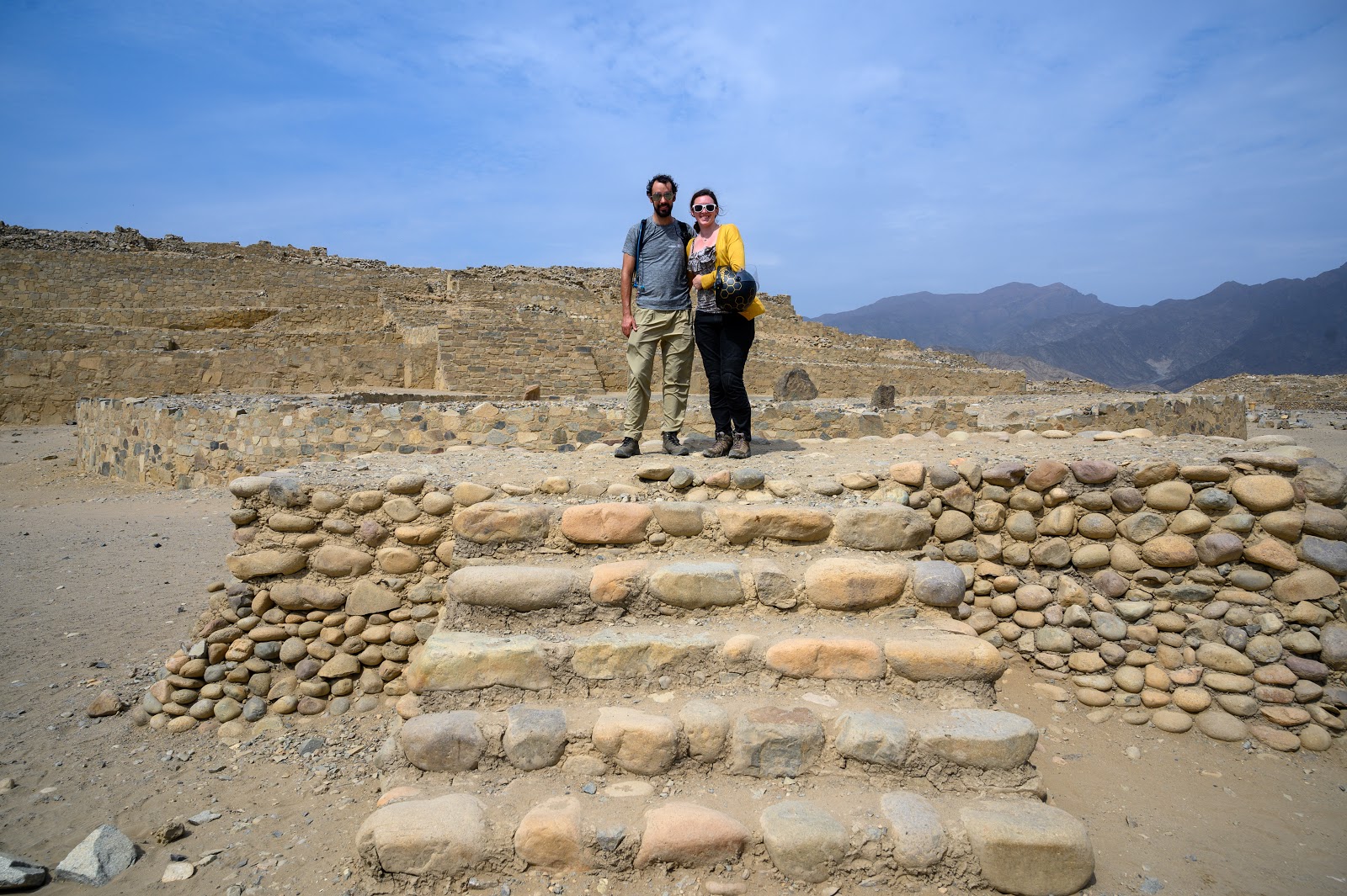
We weren't going to spend the day idle, though; Ngaire had looked up the ancient city of Caral, and finding that it was less than an hour's ride away, we rode out into the desert along a series of mostly dirt roads until arriving at the site. Caral is one of the oldest known human settlements, with the earliest parts dating back to 2600 B.C., and appears to have been the example after which the cities of many subsequent Andean cities were modeled. While the site was first discovered in 1948, serious excavations didn't start until 1994, and ramped up after the President of Peru visited the site in 2002 and allocated significant funds for its excavation and restoration. Once the centerpiece of a lush river valley and trade network involving the coast and several sites throughout the valley in which it lies, Caral was thought to be a largely peaceful society; no evidence of weapons, conquest, or war has yet been found at the site. Climate change is thought to have caused the collapse of Caral and the Norte Chico society that it anchored, as the river slowly dried up and the grasslands in which Caral would have been built turned to desert. We found the pyramids and ceremonial sites endlessly fascinating, and although our guided tour was entirely in Spanish, I was surprised that I understood enough to learn quite a bit about the site, with Ngaire filling in the gaps for me. Also got the bike a little wet on the way out.


Returning to Barranca, we got a much better sunset than the previous night, along with a much better night of sleep thanks to my stomach woes largely having cleared.


The following morning, we packed up and jumped on the bike towards Lima, the final destination of our time together in Peru. Having largely stayed out of major cities thus far, the utter chaos of driving in Lima was a bit of a shock, not least because the drivers as a whole seemed even more brazen and homicidal than in the places I'd ridden previously. I was glad to make it to our hostel in the neighborhood of Barranco, one of the more modern, supposedly "bohemian" parts of Lima. After changing and settling into our room (which had an abundance of shockingly pink linens and curtains), we hopped on a bus to try to get to the city center. I say "try" because we weren't quite sure of the route the bus was taking, and after nearly an hour and a half, much of it spent in stopped traffic, we got off and walked the remaining eight blocks or so to the Plaza de Armas.


The following morning, we packed up and jumped on the bike towards Lima, the final destination of our time together in Peru. Having largely stayed out of major cities thus far, the utter chaos of driving in Lima was a bit of a shock, not least because the drivers as a whole seemed even more brazen and homicidal than in the places I'd ridden previously. I was glad to make it to our hostel in the neighborhood of Barranco, one of the more modern, supposedly "bohemian" parts of Lima. After changing and settling into our room (which had an abundance of shockingly pink linens and curtains), we hopped on a bus to try to get to the city center. I say "try" because we weren't quite sure of the route the bus was taking, and after nearly an hour and a half, much of it spent in stopped traffic, we got off and walked the remaining eight blocks or so to the Plaza de Armas.


We enjoyed perusing the Spanish-style balconies modeled after the original buildings making up the Plaza, nearly all of which were destroyed by past earthquakes, and we were both amused by the dozens, if not hundreds of vultures perched all over the central cathedral. After walking around the Plaza a bit, we continued a few blocks onward to the Basilico y Convento de San Francisco, an elaborate church and monastery constructed in 1674. Ngaire had read about the extensive catacombs underneath the church and we'd hoped to tour them, but thinking we were too late, we thought we'd settle for simply looking around the church. We were pleasantly surprised to find that the tours ran more than two hours beyond what Google had led us to believe, and quickly made our way into the next one we could find. The monastery is an absolutely beautiful example of Baroque architecture, with intricately carved ceilings, a choir with highly realistic carvings of prominent religious figures of the time, and a stunning library containing the first known Spanish dictionary and a Gutenberg Bible dating back to the late 1500's. Unfortunately for me, photography inside the monastery is strictly forbidden, so my descriptions will have to do.
After taking in the monastery and library, we made our way down to the catacombs, which were just barely too low for me to stand up straight in. Having first been excavated for burial of churchgoer, the catacombs were eventually enlarged and connected with others throughout the city, forming a general burial site for commoners, orphans, and others who couldn't afford proper burial in a cemetery. Excavations and restoration by museum staff have resulted in an eerie, yet fascinating display of bones all along the tour route; nearly every door or gated-off stairway had skulls peering out at us, along with arrangements of bones in former burial chambers. I couldn't help sneaking one photo of the well at the lowest point we were allowed to see:

After completing the tour, we caught the city Metrobus back to Barranco, and found that it was not only significantly faster than the colectivo we'd caught earlier, but dropped off a nearly equal distance from our hostel. Live and learn, I guess. After a short nap and change of clothes, we walked a short way to a jazz bar in Barranco, where we met our friend Jorge for a late dinner and drinks. The three of us had met nine years prior in New Orleans, where Ngaire and Jorge had attended Tulane together, and he was now back in Lima teaching sociology. We had a great time catching up, some very good food and drinks, and an excellent soundtrack from the band to cap it all off.


Ngaire's flight was due to leave around 3 the next afternoon, so after packing up, we spent the morning walking around the neighborhood, enjoying the many murals and making sure to get a photo at the "Bridge of Sighs", one of Barranco's apparently famous landmarks before braving the heavy and wild traffic back to the airport. We had time to rearrange Ngaire's straining backpack and grab a quick lunch together, but before I knew it, we were saying a final goodbye as she joined the huge security line. Our time together never felt like enough, but it had been an amazing week, with some of the best scenery and hiking I'd experienced on the whole trip, and I knew we wouldn't have to be apart much longer.


No comments:
Post a Comment